Port Arthur
Do you want to know a secret? An island located across the treacherous Bass Strait, adjacent to the south eastern corner of Australia, it has been the biggest surprise of our trip so far. Tasmania was one of the last destinations we fit onto our around the world ticket. We allowed four days to explore the island, even though an acquaintance suggested that we plan more. After one day we changed our flights so we could stay a full week. It still wasn't enough.
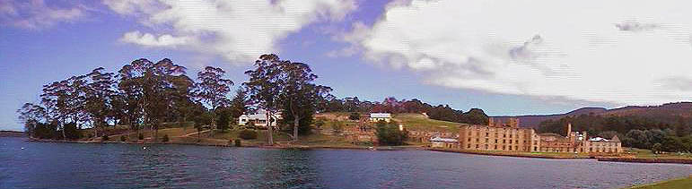
Port Arthur
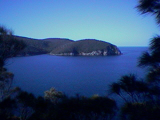
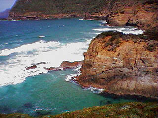
Our first destination was the Tasman Peninsula, home of Port Arthur, one of the oldest penal colonies established in Australia. The picture above was taken at the Port Author historical site and shows most of the remaining buildings where the convicts and their keepers worked and lived. Located on a beautiful bay, of which there are many along the Tasmanian coast line, it was easy to understand why the English chose this spot. Following our tour of the grounds we embarked on a forty minute sea plane tour over the peninsula. The views were stunning. Much of the shore line consists of vertical dolerite (a volcanic rock) walls rising out of the water to heights of about six hundred feet. Years of weathering have formed spectacular features. Some of them can be seen in the following pictures.
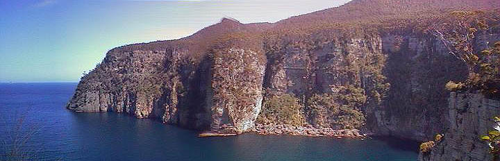
Waterfall Bay
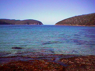
Fortuesque Bay
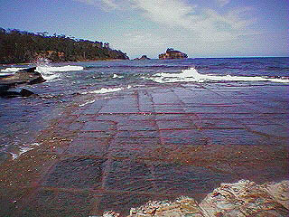
The tile phenomena captured in the photo above right is called Tessellated Pavement. It looks like a smooth ballroom dance floor. Researchers are uncertain about its development. Long stretches of coast line feature these natural tiles.
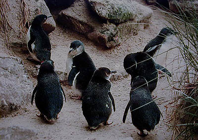
From the Tasman Peninsula we drove up the east coast to Bicheno, a recommended dive spot in close proximity to Freycinet National Park. We arrived about 7:00 pm. After surveying the lodging options we selected a beach front location. During check-in we were notified that the beach area is a protected penguin rookery, and that a free tour was included in our stay. Although a little skeptical we joined the group at about 9:00 pm. Our guide was funny and very informative. He explained that for the next two to three months the penguins would be breeding and raising their young along this short stretch of beach. Normally a female will lay two eggs. The defining feature of the area are the vegetation covered dirt embankments just up the beach. The penguins dig nest holes in the ground, which would collapse in sand. They return to the same nests year after year, and have been doing so for many generations. As we stood above the beach our guide kept pointing his flashlight at two large rocks on the water's edge.
There the penguins would gather in large numbers before feeling safe enough to run across the beach, jump over the boulders and climb up the bank to their homes. One of the parents goes out to sea each day to gather food for the chicks and returns after sunset. The other stays home to supervise. While we awaited their arrival the guide walked us along the top of the bank pointing out nesting spots. Inside you could see the adults with the two chicks. At one burrow a chick was sitting outside waiting for the meal. At an age of about six weeks they were still covered in a fluffy gray fur that would soon disappear. On the next pass of the flashlight we spotted thirty to forty penguins waiting to cross the beach. A short time later they were walking right by us in groups of five or six heading off to their families. We watched as one adult regurgitated food for a chick. Watching these cute creatures was an amazing and unexpected experience.
Fairy Penguins
The next morning we got up early to dive. In spite of the poor service we received from the dive company, we enjoyed seeing interesting sponge formations, large lobsters, and plenty of kelp forest. In the afternoon, we went to Freycinet National Park and hiked for five hours to and around Wineglass Bay (pictured below) and other beautiful, untouched areas. Many wonderful adjectives are needed to describe Tasmania: unspoiled, pristine, clean, uninhabited, picturesque, stunning, tranquil, relaxing, brilliant. The population is four hundred and fifty thousand, and all power is hydroelectric. Is the picture clear? It should be, because there is virtually no pollution.
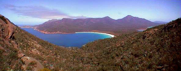
Wineglass
Bay
Unfortunately, we had to rush our tours. The next day we drove to Cradle Mountain National Park in the center of the island. On the way we stopped in Mole Creek and visited two of about two hundred caves in the area. Among stalactites and stalagmites that are hundreds of thousands of years old the glow worms put on a star- studded show. We camped in the forest and planned our hike to Cradle Mountain. Up early and on the trail by 9:00 am, we were in store for another brilliant Tasi day. We chose a three-hour return hike to Marion Lookout. This was the view upon arrival at 11:00 am.
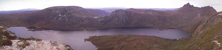
Cradle Mountain peaks on the right above Dove Lake
Needless to say we decided to carry on. We hiked along the ridge just below the peaks of Cradle Mountain, past another mountain lake where I took a swim, and down around the near side of Dove Lake. All the adjectives I mentioned above applied once again. Our hike extended to an exhausting six hours. But it was worth every steep step up and down the mountains. We enjoyed perfect weather throughout the week. Of course we can't guarantee that for your trip.
We next visited Strathgordon, site of the largest hydroelectric facility in Tasmania, and engaged in a detailed conversation about the project with a very intelligent woman representing the facility. Although there were some significant changes to the local natural landscape, these sacrifices appeared reasonable for not having to engage in pollution and radiation generating power technologies. That night we checked into the colonial Ms. Currie's House, a B&B located in Richmond, just outside Hobart. The village and our host Frank were equally charming. It was the perfect end to a wonderful, as a local called Tasmania, "heart-shaped surprise."

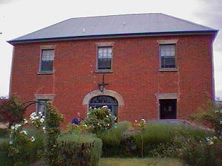
Frank & Ms. Currie's House